A never-before-seen glimpse into the Earth's geographical profile has been revealed in Singapore at a leading geospatial event.
The Earth Observatory of Singapore (EOS) delivered a presentation at the 2013 Esri Asia Pacific User Conference (APUC) on GeoTouch – a giant interactive touchscreen powered by Geographic Information System (GIS) technology.
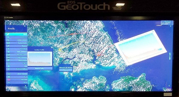
Mr Humza Akhtar, Research Associate from EOS, said GeoTouch was a revolutionary communications tool set to change how society views and shares information.
“This new age device is the perfect educational medium to teach today and tomorrow’s generations about the elements which make up the planet we live on,” Mr Akhtar said.
“GeoTouch is already being used at the Nanyang Technological University in Singapore, and I believe it will become an essential tool for students across the globe.
“Beyond the realms of academia, GeoTouch would be at home in all workplaces, including the media, to showcase major geographic breakthroughs – such as the discovery of a new volcano or a long-lost landmass.”
Mr Akhtar said GeoTouch’s value was down to its ability to easily show the Earth’s elements via a smart map.
“GeoTouch uses GIS technology to visually represent data, which ultimately translates Earth’s complexities into a universal language,” Mr Akhtar said.
“With the touch of a finger, details about every country can be revealed including cities and their population rates, names of buildings, and surrounding oceans.
“It can delve deeper to uncover the Earth’s buried terrains, like tectonic plates, oceanic trenches, and every other layer hidden beneath the surface."
In this way, GeoTouch can communicate the planet’s unseen mysteries to a broad range of observers, regardless of their technical skills, in a way never achieved before.
Mr Akhtar said GeoTouch is vital for countries like Singapore wanting to educate communities on the importance of ‘geohazards’ and planning for a sustainable future.
“Using GeoTouch, city planners in Singapore can build societies which are more sustainable for the growing population,” Mr Akhtar said.
“In addition to the current applications, we’re also working to add a real-time capability, which will allow GeoTouch to assist in monitoring issues such as climate change, urban development across continents, diseases, emergency situations, and natural disasters.
“This will enable us to identify these challenges developing all over the world – as they are happening.
“Because of this, I believe GeoTouch will eventually be a frontline decision-making tool to tackle Earth’s major complexities.”
Hosted by Esri Singapore, APUC brought together technology leaders from across the globe, including the Founder and President of Esri, Jack Dangermond.