Over the last ten years as technology has evolved, especially cloud and mobile devices, ArcGIS has transformed from a collection of software that runs on different devices, to a fully integrated cloud platform that allows the GIS practitioner to easily share their work with anyone, anywhere, anytime, on any device.
This transformation has changed the role of the GIS Manager, from managing a team of GIS practitioners that did all of the GIS work, to that of an enterprise IT system leader that focuses on enabling anyone inside, or outside the organisation, to directly use GIS technology to make better decisions and do their job. The GIS community has failed to keep up with this transformation in a few ways.
In this article from Directions Magazine on May 15, 2019, GIS Jobs: Current Industry Expectations, you can see that their research of 1,000 GIS job ads from September 2018 to January 2019 shows that the most common attributes for a GIS Manager/Coordinator position include:
- 1-4 years of experience,
- a bachelor's degree in Geography, and
- software skills that include Esri software, programming skills, database skills
Those requirements do not represent the skills required by the modern GIS Manager of a cloud-enabled enterprise IT system. The requirements now are more focused on enterprise IT system management, business, strategy, governance, innovation, marketing, change management, and workforce development.
Due to this disconnect, where most GIS manager positions are defined incorrectly, there is an atmosphere of unawareness as to what they should be doing. This has led to a chronic underutilisation of enterprise GIS in most organisations that have the technology.
Generally, people outside of GIS think of GIS just as "maps' or a graphic product, or the younger brother of CAD.
Five suggestions to get more out of your GIS:
- Promote the system
- Get a “GIS Health Check-up”
- Use a “best of breed” approach
- Consider Software as a Service (SaaS)
- Set GIS up as the central hub
This trend of underutilisation can be supported by the following three articles:
GIS is often seen as “maps” or a visual graphics product, and the more advanced capabilities are ignored because they remain unknown to key departments and decision makers.
2. Mapping the Cause: Using GIS to Determine Potential Causes for Cancer, Aug. 27, 2015
Low awareness the biggest hurdle – however, understanding the complexity and potential about this technology amongst those technology innovators is still limited. “The geospatial industry is still undervalued and underappreciated by the world at large. The onus is on us to collectively demonstrate how location data and tools can be applied to make dramatic improvements to society from making every journey safer and our air cleaner to helping businesses operate more efficiently,” underlines Edzard Overbeek, CEO, HERE Technologies.
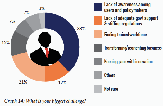
As expected, lack of awareness among users and policymakers remains the biggest challenge for the industry, with over 38% listing it as a primary hurdle... (Graph 14)
3. Disruption a bane or boon: What is the geospatial industry’s vision for 2018?, Jan. 12, 2018
This trend of underutilisation has led to an outdated image of most GIS practitioners as mapmakers. While mapmaking is a valuable and treasured skill, if an organisation has an enterprise GIS implemented, the GIS practitioners should be doing a lot more than just making maps. If the non-GIS practitioners in the organisation think the GIS practitioners only make maps, that is all they will ask for. The problem is, they want help, and need help from the GIS practitioners to apply spatial analytics to their mission, they just don't know that they can help them in this manner.
One of the first things an enterprise GIS manager needs to do is change this image. There are a few ways to do this. Internal marketing and education is one way. One easy way to start to work on this is to change your elevator pitch. Many GIS practitioners when asked what they do for a living say, "I make maps." or "I do GIS, it's like Google Maps." This prolongs the mapmaker image, therefore it is crucial that you change your elevator pitch to something like, "I help people use the power of location to make better decisions."
Rebranding is another way, there is a growing movement for GIS practitioners changing their job titles and the name of their department to remove the term "GIS" from them, to distance themselves from the mapmaker image. Examples of this include Decision Analytics, Spatial Analytics, Location Intelligence, Geospatial Intelligence, GeoAnalytics, and Location Innovative Services.
Another part of internal marketing and education is proactively changing your communication focus with non-GIS users. Most GIS users tend to focus on the technology in their communication with non-GIS users. This is not an effective mode of communication, you need to communicate with non-GIS users in ways that interest them in what you can do to help them. The best way to do this is to shift the communication focus to capabilities. A capability is "the power or ability to do something" according to Lexico powered by Oxford. Adding capabilities to an organisation and its staff will interest executives and managers. The capability that GIS can enable is best described as location intelligence. Watch this short video for a definition of location intelligence.
Enabling a new capability, like location intelligence, for an organisation and its workers, is very different than implementing technology. In 2019, Esri Canada released a report they developed with IDC called Winning with Location Intelligence: The Essential Practices. This report identifies best practices for how to be successful with location intelligence. They surveyed two hundred organisations across Canada in all industries. These organisations had 500 or more employees. They analysed their use of location intelligence and identified common best practices. They categorise these best practices into what they call the five pillars of location intelligence.
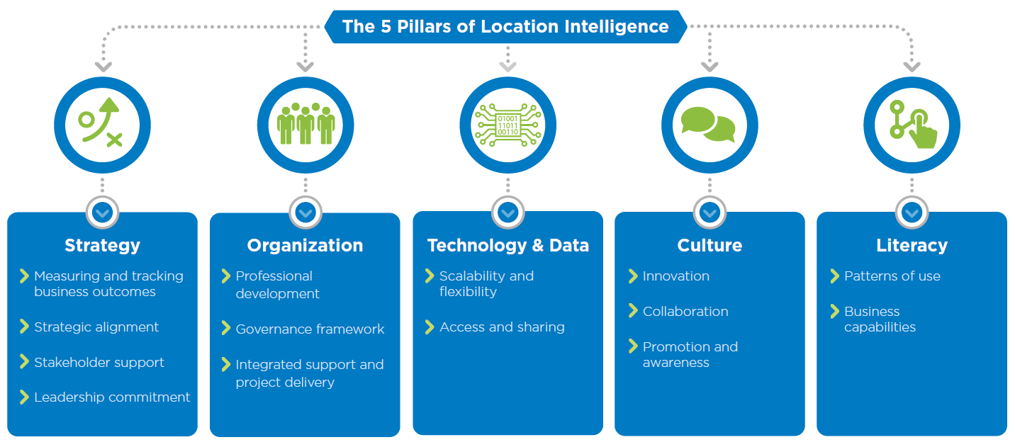
These five pillars of location intelligence help us understand in more detail the skills required of an enterprise GIS manager. You can see that you cannot spend all of your time on Technology & Data. You must dedicate time and effort to the other four. My research shows that the majority of organisations that have implemented GIS are not spending time in these other four areas. Here are five important numbers that will be revealed in this blog series:
64, 76, 78, 84, 84
Starting with the first of the five pillars of location intelligence, Strategy, why is a strategy so important? In this article from McKinsey & Company entitled, Catch them if you can: How leaders in data and analytics have pulled ahead, their survey of over 500 C-level executives and senior managers representing a full range of regions, industries and sizes showed that:
The creation of a strategy now ranks as the number one challenge to, and reason for, companies' success at data and analytics...
Once you realise you need a strategic plan, you may encounter resistance from executives regarding the dedication of resources to the development of a strategic plan. If that is the case, here is a great article from Matt Lewin of Esri Canada, Why organizations need a geospatial strategy: An executive perspective.
Here's the first of my important numbers, based on my research of 800+ GIS practitioners across the United States over the last two years:
64% of organisations that use GIS do not have, and maintain, a GIS Strategic Plan
What is a Geospatial Strategy?
A Geospatial Strategy is a business-oriented plan that defines how an organisation will use GIS to achieve its goals. An effective geospatial strategy connects your business needs with the right people, processes, and technology to help you overcome challenges and improve results.
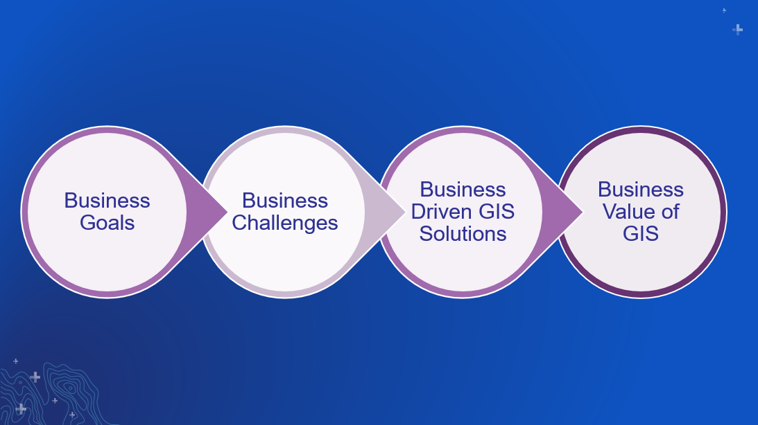
When creating a Geospatial Strategy, it is critical that you focus on the business, not the technology. Your objective is to focus your work on assisting the business. You do this by first identifying and understanding what the business goals are, these should be documented in strategic plans, initiatives, Key Performance Indicators, etc. Then you identify and understand the challenges that the organisation is facing that are keeping it from achieving the goals. Then you deploy GIS solutions that overcome the challenges so the goals are achieved. This results in real business value of GIS.
For more information on the Esri Best Practices on how to create a Geospatial Strategy, please check out this document, The Approach to Maximize Impact and be sure to contact your Esri Account Team.
You can discover more ways to get the most out of your GIS by contacting an Esri specialist via email or calling 6742 8622.