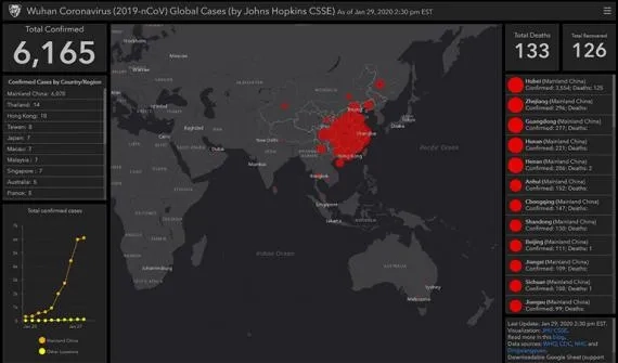
You are here News and events News News Search news Search by year All20252024202320222021202020192018201720162015201420132012 Tags - Any - ArcGIS Pro: Essential Workflows3DABSAECAgileAgribusinessAgricultureAnalyticsAppsAppStudioArcGISArcGIS 10.5ArcGIS 10.6ArcGIS EnterpriseArcGIS Experience BuilderArcGIS Field MapsArcGIS HubArcGIS IndoorsArcGIS KnowledgeArcGIS OnlineArcGIS ProArtificial intelligenceAsset managementAugmented realityAustralian Bureau of StatisticsAutodeskBankingBIBig DataBig Data AnalyticsBIMBorder PatrolBusinessBusiness IntelligenceCadastreCalifornia CoastlineCitizen engagementCloudCloud computingCloud GISCollectorCommercialCommercial propertyCommunityConstructionContentCoronavirusCouncilCOVID-19CrisisCrowdsourcingDataData analyticsData visualisationDeep learningDefence and intelligenceDekhoDesignDigital transformationDigital twinDisruptive appsDronesEducationeLearningElectionElectorateElectricElectricityEmergency managementEmergency responseEmergency servicesEnergyEnergy, oil, gas and renewablesEngineeringEnterprise GISENVIEnvironmental managementEsriEsri AustraliaEsri Petroleum ConferenceEsri UCEsri Young Scholars AwardEventsFacility managementFederal governmentFinancial institutionsFinancial servicesFleet managementFood securityForestryGasGDA2020GDA94Geo hubGeoAIGeoAnalyticsGeoBIMGeographic datumGeographic Information SystemsGeospatial AnalyticsGetting Started with ArcGIS ProGISGIS for schoolsGIS managerGIS server softwareGIS technologyGIS trainingGIS web servicesGovernmentHealthHealth and human servicesHomeland SecurityIcon WaterIDLImageryImpact AwardsIndoor navigationInnovationInsights for ArcGISInsuranceInsurance and BankingInteractive mapsInternet of ThingsInternshipInteroperabilityIntroduction to ArcGIS Pro for GIS ProfessionalsIntroduction to GIS Using ArcGISIoTJack DangermondJavaScriptKerajaan Negeri SembilanLand AdministrationLand managementLaura DangermondLaw enforcementLive dataLive sensorsLocal governmentLocation intelligenceLocation-based analyticsLogisticsMachine learningMapping and chartingMapsMaritimeMediaMicrosoft AzureMiningMobileMobile applicationsMobile GISMount AgungNational developmentNational SecurityNot for profitOH&SOilOpen dataOpen platformOperational awarenessOz MineralsOzriPartnershipPetroleumPETRONASPlanningPortsPredictive analysisProductsPublic safetyPublic sectorQueensland GlobeRaster dataReal-time analyticsRemote sensingResilient communitiesResourcesRetailROISaaSSabah Lands and Surveys DepartmentSafe communitiesSAG AwardsSAPSAR ImagerySARscapeSatellite imageryScholarshipSensorsSituational AwarenessSmart citiesSmart communitiesSmart transportSmarterWXSolar eclipseSpatial data infrastructure solutionsSpeculative designStartupsState governmentStoryStory mapsSupply chain managementSurvey123Sustainable developmentTelcoTelecommunicationsTrainingTransformationTransportTransport analyticsTransport and InfrastructureTransportationUIUnearthed ChallengeUnited NationsUnmanned Aerial VehiclesUrban analyticsUrban planningUser experienceUser interfaceUser researchUtilitiesUtility networkUXUXGVirtual realityWaterWaterfallWeb GISWHO Innovating efficient and green construction with GIS Discover how ACCIONA leverages ArcGIS online to transform engineering projects, cutting cost, boosting collaboration, and accelerating the shift to a low-carbon future. Learn more GeoInnovation Singapore 2025: Paving the way for a smarter and safer future At GeoInnovation Singapore, over 200 industry leaders gathered to celebrate location intelligence and its role in shaping a smarter, safer Singapore, alongside the award winners. Learn more Singapore organisations demonstrate cutting-edge GIS skills on a global platform Sustainable development and operational efficiency drive Singapore organisations to global heights. Learn more News Inaugural GeoInnovation Awards 2024 crown innovative applications Five organisations were recognised for implementing innovative GIS solutions across a number of industries that serve the city state and its local communities. Learn more News World-leading real-time location intelligence powers the National Day Parade 2023 Esri is celebrating National Day with Singaporeans by harnessing the power of Geographic Information Systems (GIS) to enhance the National Day Parade (NDP) celebrations. Learn more News Celebrating innovation in GIS application Singaporean organisations were recognised at the 43rd annual Esri User Conference in San Diego. Learn more News NParks drives a tech-led approach to social distancing Leveraging GIS technology, the National Parks Board developed innovative ways to safeguard communities during the pandemic. Learn more News Singapore's 100 Women in Tech Esri Singapore's lead spatial geospatial consultant, Sharon Gin - named among the nation's 100 women in tech - shares her insights on how to leverage innovative technologies to address complex challenges. Learn more Esri Singapore and MPA take Singapore's marine landscape to new depths Learn more Mapping the big picture Learn more Esri acquires nFrames to enhance its 3D capabilities Learn more NUS-SDE signed MOU with Esri Singapore to expand research in geospatial analytics Learn more An increased demand for geospatial education and professionals Learn more Digitally transforming the urban landscape Learn more GE2020: Using a smart map to present insights and analysis Learn more Esri named a leader in location intelligence platforms report Learn more Esri partners with WHO as part of COVID-19 response Learn more SLA launches the 3D Singapore Sandbox Learn more Real-time map tracks Coronavirus outbreak Learn more Esri and NUS launch the Boustead-Esri Geospatial Scholarship Learn more Load More
Innovating efficient and green construction with GIS Discover how ACCIONA leverages ArcGIS online to transform engineering projects, cutting cost, boosting collaboration, and accelerating the shift to a low-carbon future. Learn more
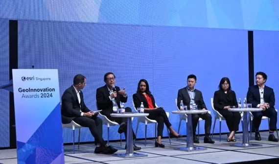
GeoInnovation Singapore 2025: Paving the way for a smarter and safer future At GeoInnovation Singapore, over 200 industry leaders gathered to celebrate location intelligence and its role in shaping a smarter, safer Singapore, alongside the award winners. Learn more
Singapore organisations demonstrate cutting-edge GIS skills on a global platform Sustainable development and operational efficiency drive Singapore organisations to global heights. Learn more
News Inaugural GeoInnovation Awards 2024 crown innovative applications Five organisations were recognised for implementing innovative GIS solutions across a number of industries that serve the city state and its local communities. Learn more
News World-leading real-time location intelligence powers the National Day Parade 2023 Esri is celebrating National Day with Singaporeans by harnessing the power of Geographic Information Systems (GIS) to enhance the National Day Parade (NDP) celebrations. Learn more
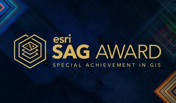
News Celebrating innovation in GIS application Singaporean organisations were recognised at the 43rd annual Esri User Conference in San Diego. Learn more
News NParks drives a tech-led approach to social distancing Leveraging GIS technology, the National Parks Board developed innovative ways to safeguard communities during the pandemic. Learn more
News Singapore's 100 Women in Tech Esri Singapore's lead spatial geospatial consultant, Sharon Gin - named among the nation's 100 women in tech - shares her insights on how to leverage innovative technologies to address complex challenges. Learn more