With a total of 25 buildings spread over 305,000 sqm, first-year students and visitors to Nanyang Polytechnic (NYP) can sometimes find it challenging to locate a specific room.
So, its School of Engineering – with funding from the Singapore Land Authority – created the Nanyang Polytechnic Campus Navigation System earlier this year. It will be rolled out to all users in its campus in the coming months.
Using location-based analytics, the system provides a detailed map of the campus. Beyond its ability to pinpoint the exact locations of lecture halls, tutorial rooms and other facilities in the polytechnic, users will also be guided to their desired destinations using the most efficient routes.
This capability is not limited to two points on the same level, and even utilises lifts, escalators and stairways to provide easy navigation to all corners of the campus – a feature not available in other mapping platforms.
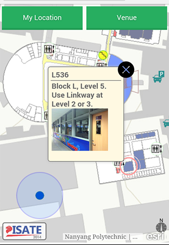
Staff and students can access this service through an Intranet web application. Visitors who are logged onto the campus guest Wi-Fi can also make use of this service – all they have to do is scan the QR code.
“Nanyang Polytechnic welcomes more than 4,000 new students and visitors annually. With seven different schools and over 30 corporate departments, it can be challenging for people unfamiliar with the campus to find their way around. For our School of Engineering students, the process of development has enabled them to experience first-hand the application of technology as a solution to everyday problems,” said Dr. Kong Wai Ming, Deputy Manager at the School of Engineering, Nanyang Polytechnic, who leads this initiative.
Dr. Kong added that the database can be used for future on-campus location analytics projects. For example, NYP is currently developing an integrated campus navigation system catered to the visually impaired. The system will provide an audio description of the prescribed path when guiding users to their desired destination.
Additionally, Dr. Kong noted that the use of location-based technology in navigation systems can be applied to areas with a high volume of visitors, with certain hospitals expressing interest in replicating this platform.
Speaking at the 2017 Esri Singapore User Conference, Dr. Kong shared how the students and staff at NYP developed the navigation system and how users have benefited.
The Esri Singapore User Conference is the country’s largest annual geospatial event, with over 700 professionals attending from the commercial, government and education sectors.