The Urban Redevelopment Authority (URA) and Jurong Port received the prestigious Special Achievement in GIS (SAG) Award today at the 44th Esri User Conference in San Diego, United States. This accolade recognises their leadership in setting new standards for efficiency and productivity within their respective fields through their innovative use of geospatial technology.
The SAG Award, presented annually, honours organisations spearheading cutting-edge projects that utilise Geographic Information System (GIS) technology to drive positive change.
During the conference, URA and the National Parks Board showcased their collaborative efforts in managing a City in Nature through GIS-enabled, business-focused, enterprise-grade systems.
Transforming Urban Planning with Integrated 3D Data
URA's winning project, the Integrated 3D System of Record on ePlanner, empowers users to easily tap on a whole suite of data-driven urban planning and design capabilities to enhance planning work. Built on Esri’s ArcGIS Enterprise, ePlanner centralises diverse 3D data formats previously managed by separate specialised software.
It integrates existing 2D GIS records with comprehensive 3D information on buildings, trees, and roads, 3D Point Clouds and Building Information Modelling (BIM) alongside urban massing simulations.
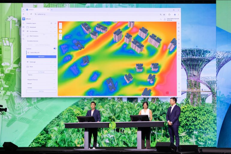
This integration enables over 1,600 government officials, including planners and architects, to access and analyse geospatial data for various projects across different agencies in Singapore.
Productivity gains and new capabilities in advanced modelling and simulation have significantly enhanced the quality and precision of urban planning and design in Singapore, which helps in the realisation of plans to create a more liveable environment for residents.
ePlanner also expedites decision-making and enables stronger collaboration among government agencies by supporting spatial analyses directly on web browsers.
Mr Julian Cheng, Deputy Director of URA's Design & Planning Lab, said: "By streamlining access to spatial data and enabling real-time analysis, ePlanner has enabled stakeholders across government agencies to collaborate more efficiently and make informed urban planning decisions. URA is privileged to receive the Esri Special Achievement in GIS Award, which underscores our commitment to leverage technology to enhance our efforts to make Singapore a great place to live, work and play."
Enhancing Port Operations with Location Intelligence
Jurong Port achieved significant operational efficiency improvements with JP Glass, a comprehensive data visualisation platform powered by geospatial technology. JP Glass consolidates data from multiple sources into ArcGIS software solutions, to provide a 360-degree overview of port operations, enabling informed assessments of resource allocation and optimise turnover rate and turn over time of vessels, ultimately enhancing overall productivity.
Integrated seamlessly with existing Jurong Port systems, JP Glass delivers real-time insights into port activities such as equipment and warehouse tracking. Interactive dashboards enable continuous monitoring of progress and performance metrics, ensuring smooth operations.
Additionally, JP Glass provides real-time updates on vessel activities, offering detailed information on characteristics such as commodity types, consignee specifics, weight, arrival times, activity durations, and cargo handling progress. These features empower strategic operational evaluations and maximise vessel handling efficiency.
The platform also fosters collaboration across departments, promoting efficient port management and effective planning. This digital transformation is part of Jurong Port’s strategy to boost operational productivity through process optimisation, thereby delivering better customer service for our port users.
“JP Glass empowers us to see our entire operation in one place,” said Ms Cynthia Mark Mohan, Assistant Vice President and Head of Digitalisation at Jurong Port. “This comprehensive view translates to improved resource allocation and a smoother flow of goods through the port.”
Singapore's Commitment to GIS Excellence
Mr Joe Lee, CEO of Esri Singapore, said the recognition of URA and Jurong Port underscores Singapore's commitment to leverage Esri’s cutting-edge GIS technology for smarter urban development and port management.
“These acclaimed solutions demonstrate GIS’ transformative impact, enhancing efficiency and data-driven decision-making. Ultimately this improves the sustainability and competitiveness of Singapore,” Mr Lee said.
If you would like more details or have any questions, please contact the media team.