In today's dynamic urban landscape, cities worldwide deal with unprecedented challenges in balancing growth with sustainability. Singapore, renowned for its effective urban planning amidst limited land resources, exemplifies this balance through innovative approaches led by the Urban Redevelopment Authority (URA).
URA’s mission is to enhance urban living in Singapore by building resilience in the face of diverse challenges. As a densely populated city-state, Singapore must manage its advanced defence and utilities infrastructure alongside meeting basic urban needs like housing, retail, and social services. These shape Singapore's urban development strategies, requiring innovative approaches to ensure sustainable growth and liveability.
Establishment of the Design and Planning Lab
Central to URA's strategy is the formation of Design and Planning Lab which drive the adoption of digital tools for urban planning and design, and to serve as a catalyst for skills, ideas, and insights. The lab takes an integrated end-to-end approach, focusing on data governance, platform and services, and experienced planners and architects working at the intersection of domain and technology.
Challenges
One of the key initiatives of this division is to increase the use of 3D analytics, modeling, and simulation in urban planning and design, optimising plans for improved outcomes. These allow planners to swiftly assess and refine urban scenarios prior to implementation, e.g. testing wind flow and rain patterns to enhance urban design efficacy. Nonetheless, this initiative presents challenges, including:
- The management of diverse 3D datasets,
- Most of 3D data are often non-interoperable
- Costly hardware and software
- The need for specialised skills, and
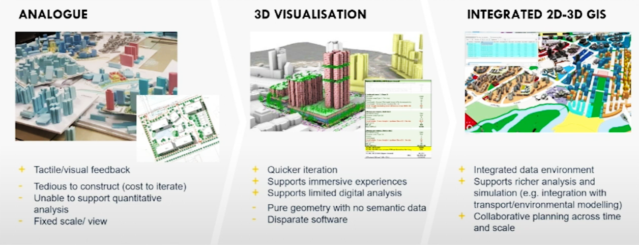
- Evolving practice from traditional analogue to 3D visualisation to integrated 2D-3D GIS

Leveraged ArcGIS technology to develop 2D – 3D system of record
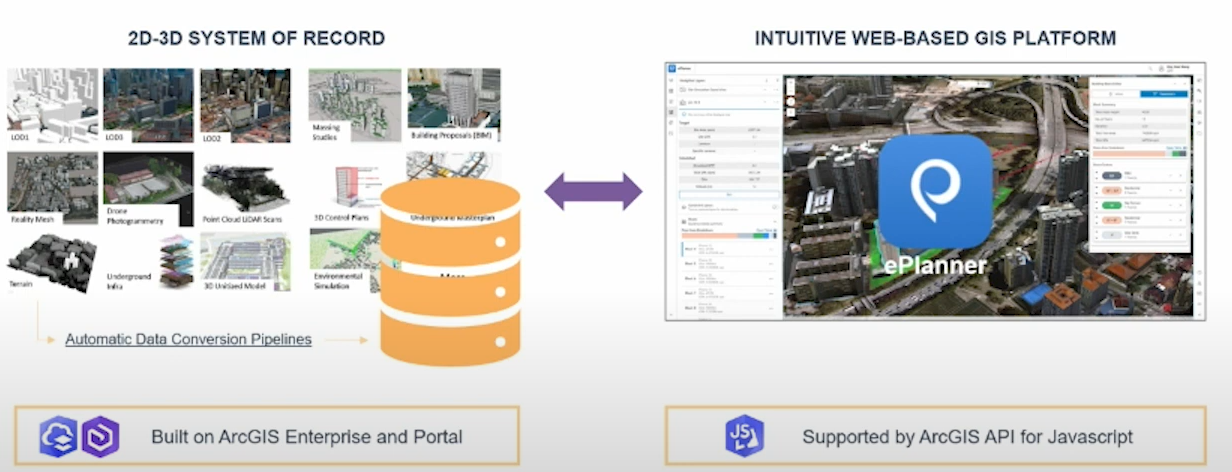
The initial step involves URA constructing the 3D system of record. This process involves gathering diverse forms of 3D data in various formats and establishing automated pipelines for data conversion. Then, these datasets are incorporated into a comprehensive Geographic Information System (GIS) as system of records built on ArcGIS Enterprise and Portal. This integrated approach ensures that all relevant 3D data is effectively managed and accessible, for informed decision-making.

Enhancing the E-planner 3D platform
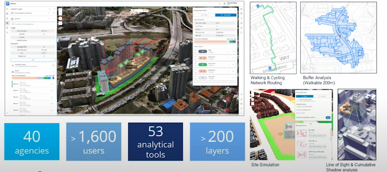
The second initiative is upgrading the E-Planner platform beyond its original 2D GIS workflow tool. It now supports a wide range of 3D datasets, including urban models, BIM models, point clouds, and underground models which is supported by ArcGIS API for Javascript. This upgrade includes modular modeling and simulation capabilities that are crucial for planning complex scenarios across different areas like environmental modeling and transportation analysis. These advancements also enable quick generation and testing of various urban options and scenarios using URA's specialised tools within E-Planner.

“E-Planner facilitates over 1,600 planners and architects across 40 government agencies to conduct data analytics and 3D simulations seamlessly.” stated Julian Cheng, Deputy Director of URA's Design & Planning Lab.
“This web-based GIS platform democratises access to advanced planning tools, reducing dependency on specialized software and enabling efficient decision-making and collaboration among stakeholders in urban projects.”
Future updates, URA aims to expand the E-panner beyond government agencies to include industry and research communities. The upcoming E-Planner X initiative will introduce an internet-based platform for collaborative innovation, allowing stakeholders to contribute new capabilities and insights. This expansion underscores URA's commitment to fostering a broader community engagement in shaping Singapore's sustainable urban future through advanced digital planning tools.
Watch URA's presentation:
Conclusion
URA's initiatives exemplify Singapore's proactive approach to urban planning challenges through digital innovation. By leveraging 3D analytics and simulation, URA not only enhances planning accuracy and efficiency but also strengthens urban resilience in the face of evolving global trends. As URA continues to evolve its digital capabilities and expand collaborative platforms like E-Planner, Singapore is poised to maintain its status as a global leader in sustainable urban development.
Contact us to learn more about the role GIS plays in building smarter liveable cities or call 6742 8622 to speak with the specialist.

